Topographic Maps
Topographic maps contain data on the natural features of the land, such as elevations, contours, water bodies, and other features, plus they may also contain man-made features such as roads, railroads, buildings and structures, etc. The main concept of topographic maps is that they show the way the landscape would appear if viewed from above. A brief history of the USGS topographic map program describes the creation of this valuable series. For more on the USGS topographic maps, see:
General Information About Topographic Mapping. Introduction and history of the entire system.
USGS Maps. Description of each topo map series (differing scales and types).
The UB Map Collection includes topographical maps of the entire United States at scales of 1:24,000, 1:100,000, and 1:250,000; a complete set of Canadian topographic maps at 1:25,000; 1:50,000 and 1:100,000; World maps at 1:250,000 and 1:1,000,000; and maps of Europe, Mexico, and other areas at more detailed scales. U.S. topographical maps are arranged alphabetically by state, and then alphabetically by map name.
Use Index maps to locate topographic maps for the U.S. and Canada. In addition to printed maps, digital maps are available:
- Topographic Maps (Digital Rasterized Graphic) image files for download (for use in ArcView, Photoshop). Also available here are low-res images of each quad.
- New York Topographic Maps (selection). Topos (Scales 24k, 100k, 250k) covering selected portions of the state. Download as jpg or pdf.
Current USGS Topographic Maps
In addition to topo maps in our collection, you may want digital or digitized topo maps to download. There are many ways to access these, including:
The US Topo: Maps for America (U.S.) This USGS site is the best source for topographic maps of the United States. View and download raster images of topo maps, searching by a variety of elements. Maps may be located and downloaded at no charge. Paper maps are available for a fee through map stores, and also in the USGS Map Store.
Historical (pre-1950) USGS Topographic Maps
Historic or pre-1950 topographic maps (mostly 1:63,360) of New York State are available in the Map Collection. These can be located using the Libraries' Catalog, and are available for use inside the Map Room. Ask for assistance at the UGL/SEL reference desk. An index is available at several external sites:
- Historic Maps of New England and New York state, or the
- MyTopo site (commercial site; some restrictions for use).
Both websites also provide direct access to image files of the topo maps. MyTopo now offers historic topo maps for the following states: Connecticut, Delaware, Maine, Maryland, Massachusetts, New Hampshire, New Jersey, New York, Ohio, Pennsylvania, Rhode Island, Vermont, Virginia, and West Virginia.
Historical Topographic Map Collection (National Map (USGS)). Digital versions of U.S. topographic maps for all states, both current and pre-1950s, may be located here.
Examples of Buffalo topos can seen here: Historical Topographic Maps of Buffalo.
How to Read and Understand Topographic Maps
USGS Topographic Maps. USGS page describing terms and concepts relating to topo maps.
Topographic map symbols. Though somewhat uniform throughout the cartographic world, not all maps use the same symbols.
USGS Topographic Maps - The largest collection of maps in the Map Room are the U.S. government produced topographic map series. Below are numerical statistics on the number of USGS Topographic Maps in various series from the National Topographic Map Names Database.
| Scale of Series | Number of Maps |
|---|---|
| 1:24,000 | 53,252 |
| 1:25,000 Alaska | 237 |
| 1:25,000 7.5" X 15" | 192 |
| 1:63,360 Alaska | 2905 |
| 1:100,000 | 1813 |
| 1:250,000 | 663 |
| American Samoa | 11 |
| Guam | 20 |
| Micronesia | 76 |
| Mariana Islands | 28 |
| Puerto Rico | 95 |
| Virgin Islands | 24 |
A summary of the system is this description from the USGS site:
USGS Topographic Mapping 1879-1992
The USGS took over responsibility for mapping the country in 1879 and has been the primary civilian mapping agency of the United States ever since. The best known USGS maps are the 1:24,000-scale topographic maps, also known as 7.5-minute quadrangles. More than 55,000 7.5-minute maps were made to cover the 48 conterminous States. This is the only uniform map series that covers the entire area of the United States in considerable detail.
The 7.5-minute map series was officially completed in 1992, and the program has recently been replaced by The National Map.
Sample topographic maps:
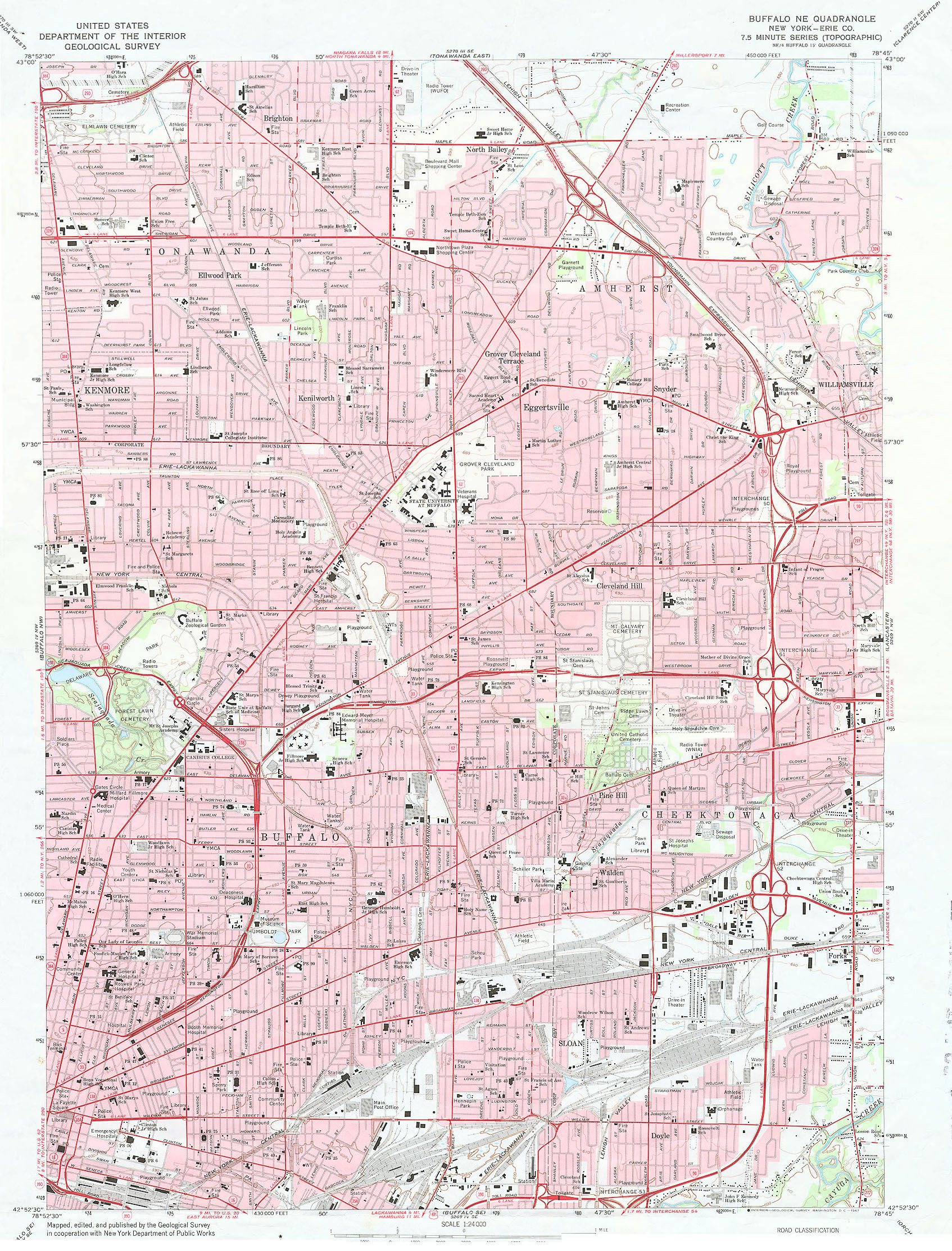 Buffalo, NE Quadrangle map. 1:24,000 topographic map of the Northeast part of Buffalo, and surrounding suburbs, produced by the U.S.G.S.
 (1503KB jpg image)
Call Number: U.S. State Topographical map section: Arranged alphabetically by title.
(For an index to Western New York State 1:24,000 scale maps, go to the low resolution Map Index (Western NY). The entire state is broken into four sections. All four are 8.5 by 11 inch Acrobat format (PDF) files. (Note: These files are large and will display and print more efficiently if saved to disk and opened in the Acrobat Reader software outside of your Internet browser.)
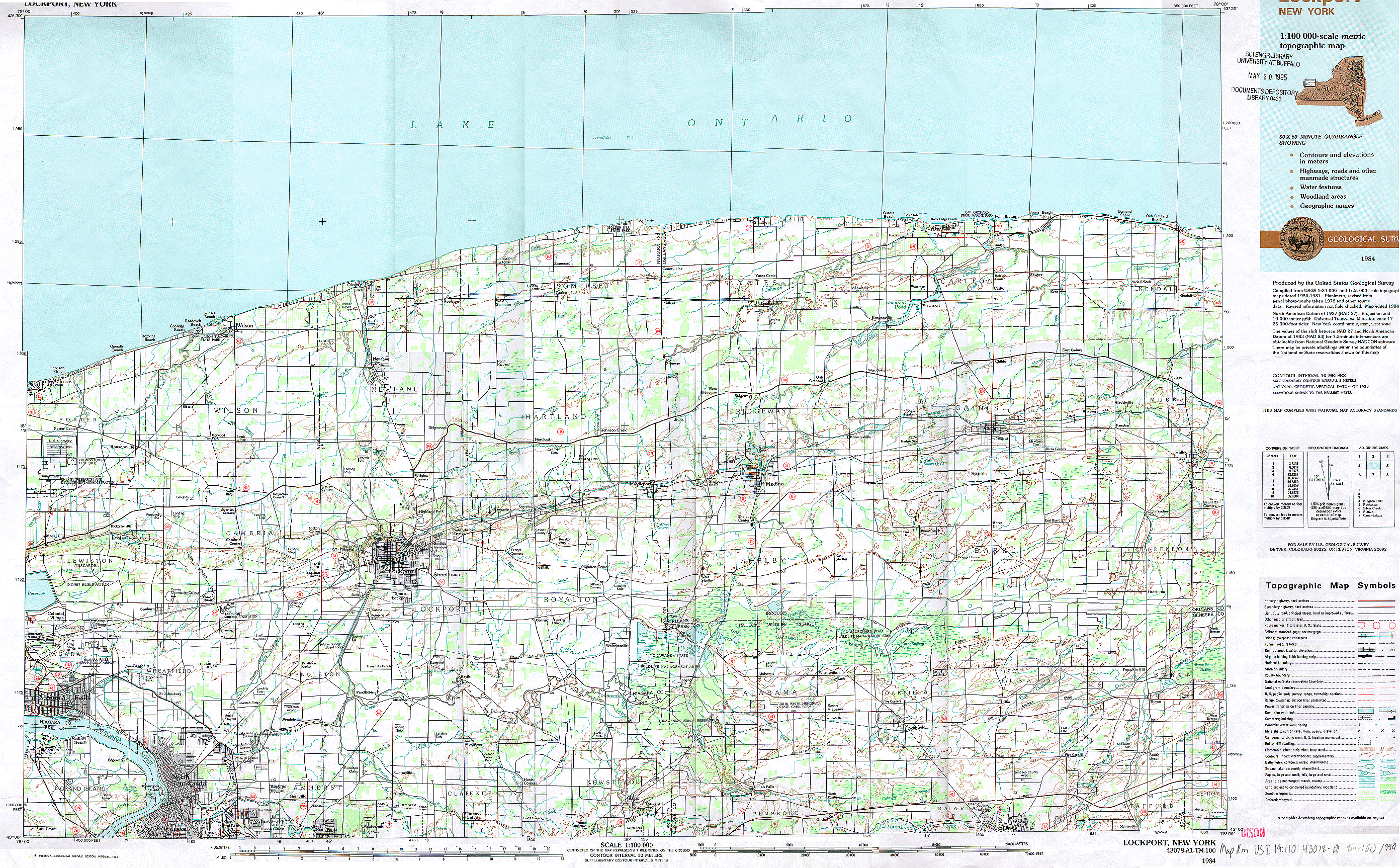 Lockport, NY. 1:100,000 topographic map.
(2703K GIF image)
Call Number: US I 19.110 : 43078-A1-™-100/994
State Digital Topographic Map Sites
- Kentucky 7.5 Minute Topographic Quadrangles (DRG)
Other United States Topographic Maps
- Army Map Service 1:250,000 Scale Topographic Maps of the United States. UB has most of these maps in its collection, see the Libraries' Catalog for access. The link above is an index of all maps in the series. Click here for Alaska.
Ordering Topographic Maps
To order USGS maps, visit the USGS Store with order information. Topos may be downloaded at no charge on the USGS Topographic Maps download site.